
Carrauntoohil
The highest point in Ireland is a lovely peak named Carrauntoohil. As much fun to climb as it is to say, it is technically challenging in a way many higher peaks are not. A lot of mountains have manicured or at least clear trails that make the trip to the summit more of a grind or slog, rather than a challenging experience. Caarauntoohil is varied, and definitely not a slog. Depending on your route there is quite a bit of scramble and scree involved, which makes this one of my personal favorites.
Carrauntoohil is located in the delightfully named Macgillycuddy’s Reeks, a mountainous region in County Kerry. Kerry is known for its rugged terrain and highlands, which we found to be haunting and beautiful, in a dark and forlorn way when the sky was overcast, and sparkling when the sun was out, which was less often than not. It was more than a little fulfilling to trek through the hills and rocks with the sheep and goats for company.
The whole of Macgillycuddy’s Reeks are privately owned, so any climbing or hiking you do needs to keep the landowners in mind. Pack it in, pack it out, and respect the land you’re on.
Our hike up the 3,406’ (1039 m) took 3.5 hours up and 2.5 hours down. We were not hurrying so you could speed run this at 4 hours or less, but we suggest taking your time the first time around. We took breaks and enjoyed the view, which was immaculate. You’ll need sturdy shoes or boots for this climb, and you could benefit from hiking poles or a walking stick. A rain jacket would be a good idea, and a dry bag for your camera if you bring one. Some snacks for the top, and that should be about it. Carrauntoohil isn’t an all day excursion unless you want it to be. Remember to take with you whatever you brought in.

There are several ways up Carrauntoohil. Heather and I chose a popular starting point, Cronin’s Yard. There is a parking lot where you can leave your car for €2, cash only, and when they are open there is a café and toilet facilities. The Yard has camping pods and it looked like there was space for tents, as well as tables and a concrete courtyard with other paraphernalia for hikers. The path to the mountain is close at hand and leads past and through the sheep pastures along a creek.
A second starting point is from a trailhead in Lisleibane, where one can park for free. There are not facilities there, so choose wisely. Both paths meet up rather quickly though, on flat ground and before any ascent begins.
There is a third path from a car park northwest of the peak, by a water treatment plant. This route cuts out a lot of the more fun parts though. If you want an easier trek, I suggest starting here.
There are two green bridges to cross the River Gaddagh from the first two starting points, which name is presumptuous for such a small waterway but we didn’t name it so carry on. After this you must make a choice for your ascent. The southern trail is easier AT FIRST, but leads you to the Devil’s Ladder, which makes up for the earlier, misleading path of least resistance. Plan on at least an hour going up the Ladder, especially if it is wet. If it’s raining, I suggest the other way, though there are some rocky, slick parts that way as well. The Ladder is steep, all manner and size of rock, and will require climbing at times. If it is slippery it will be dangerous. Be warned that deaths have occurred on Carrauntoohil; it may not be a fourteener in the Rockies, but it holds perils of its own, mostly to do with weather, poor footing, and taking routes that are more technical or challenging than you can handle.
Looking down from the top of the Devil’s Ladder

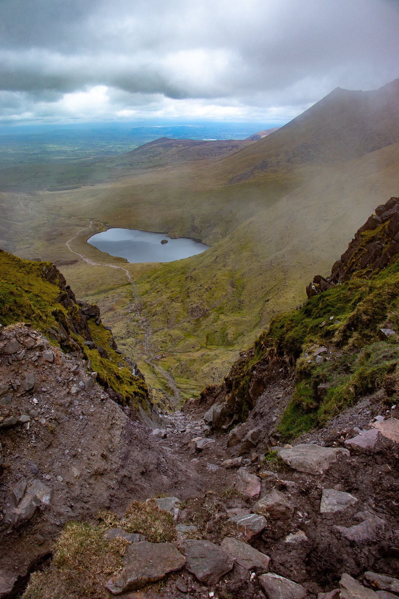
Lough Cummeenoughter
After the Devil’s Ladder it becomes much easier going again. You are still climbing and there is some scree but it is comparably simple to gain the summit from here.
As for the other fork back at the River, to the right when facing the summit, the going is a little rougher the whole way, but only a small section past the last lake is rock and climbing, much nearer the summit. This path also splits in places but it is fairly easy to aim for the top by this point. You will have to choose between taking a northern, right hand, path again which will lead you past the Hag’s Tooth, an outcropping point of rock that offers a better and unobstructed view of the valley, or the southern path which leads to Lough Cummeenoughter. The lake is the highest in Ireland, and though small in stature, overflows with a serene beauty.
If you take the Lake path, it’s a tough half hike, half climb to the ridgeline, which may take 30-60 minutes depending on your pace. Once you’re up, there is a firm rock ascent with a few switchbacks, and you could be in some cloud cover. We had decent visibility, with clouds blowing in and out.
At the top you’ll find plenty of small rocks, a cool rock fort, and a cross. You’ll have your choice of descents, and we suggest going down one of the other routes to get a full taste of the mountain. It would be a shame to come all this way and avoid a place called the Devil’s Ladder, right? Head down an established path and do not try to create your own. Be safe. If there is a lot of rain, the rocks may become slippery, and there have been fatalities on this mountain before.
We give Carrauntoohil a 10/10 because it is a beautiful, fun hike that includes some actual climbing, but doesn’t take more than a day to do. We would definitely do it again.


Pictures from the summit of Carrauntoohil